|
SAR reflectivity data are used in hydrology for flooded area detection and mapping.
Typically, flooded areas remain cloudy for many hours after an event and the advantage of using SAR data
compared to optical data is mainly given by the all-weather capability of radars.
High resolution images obtained by COSMO-SkyMED and TerraSAR-X radar systems can be used for generating very accurate and detailed maps.
COSMO-SkyMED constellation images allow improvement of hydrological applications for two main reasons.
Moreover, thanks to the the very short revisit time of the COSMO-SkyMED constellation, it is possible to evaluate the flooded areas just after the peak of flooding.
Indeed, in case the satellite acquisition is too late with respect to the time of the event, the evaluation can be misleading or even impossible.
Finally, in case of large events, the short revisit time allows for a monitoring of the event with the possibility to investigate the event history.
|
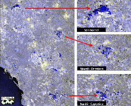

Test Site: Salento, South Italy (2-3/11/2010)
COSMO-SkyMed stripmap data. Flooded areas are coloured in blue
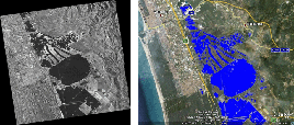
Test Site: Massaciuccoli Lake, Italy (28/12/2009)
COSMO-SkyMed Enhanced Spotlight data
|

